Tag Archives: map

The Historical Context

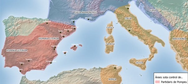
The Civil War between Julius Caesar and followers of Gnaeus Pompeius (BC 49-45)

The excavations carried out so far have given a date for the destruction of Puig Ciutat at the end of the Roman Republic, possibly during the Civil War between followers of Julius Caesar and followers of Gnaeus Pompeius. The map shows the area of influence of the two sides in the moments before the Battle of Ilerda (49 BC), when Caesar had control over Gaul and Pompey over a large part of Hispania. The regions under the control of the Roman Senate also supported Pompey.

Historical sources mention the movement of Caesar’s troops from Marseille to Hispania via unidentified points of the Pyrenees to confront Pompey’s followers, who had taken up position in Ilerda (Lleida).

The Geographical Context

Exploring Lluçanès

Puig Ciutat is located in the area of Lluçanès, a raised plain separating the Ter and Llobregat basins. Although the region has a long history of north-south seasonal herd migration, it’s also clear that there were long-distance routes between the two basins and beyond.

The work of reconnaissance of the terrain and the spatial analysis by the Puig Ciutat team have revealed numerous archaeological sites from ancient times and allowed the start of research on east-west communications in Central Catalonia.

The following image shows a suggested route for the main communications routes crossing Lluçanès in Antiquity and points where archaeological remains have been located. (Source: Cartographic base of the Institut Cartogràfic i Geològic de Catalunya (Cartographic and Geological Institute of Catalonia), accessible on www.icgc.cat).

The Local Context

A Game of Strategy

Puig Ciutat stands in a meander of the Gavarresa stream, which provides a natural defence along part of its perimeter but gives it little long-distance visibility. Occupation of this site, then, probably didn’t respond to the strategic advantages of this meander.

What did the inhabitants of Puig Ciutat defend or control? When was it destroyed? At the end of the Roman Republic? Where was it attacked from? What factions could assailants and besieged have belonged to?

As we’ve seen, some of these questions have now been answered thanks to the work carried out so far.

To solve these mysteries, the Puig Ciutat team is applying traditional archaeological exploration as well as geophysical archaeology or remote sensing over a large area surrounding the site.

Picture: © LIDAR data property of the Institut Cartogràfic i Geològic de Catalunya.